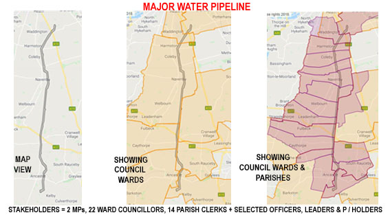
Political Mapping of Pipeline & Cable Assets

Mapolitical Managed Services - providing Integration of New and Existing Major Gas, Water & Sewerage Pipelines and O/H Power & Buried Cable Routes into Mapolitical

We have developed the software and processes to take GIS shape files (geoJson, wkt etc) of any pipeline or power cable route and integrate it into the Mapolitical App. This enables an immediate Political Map of the route to be formed, so that key stakeholders can be contacted.

Example Water Pipeline and Immediate Communication Benefits

The above screen-shot image shows a major water pipeline which was integrated into Mapolitical for a large Water Utility. This shows the location of the pipeline and how it relates to MPs, District and County Councillors and also to Parish Councillors/Clerks. In all, 38 key political stakeholders were found, not including the built in system feature option of finding additional L.A. Officers (e.g. CEOs, Chief Planning, Environmental, Econ Development etc.), Leaders and Portfolio Holders.

Keeping local communities aware of major backbone core assets, new build consultation, planning and construction, maintenance and incidents shows a professional approach to the Public Relations of key stakeholders.